748.4 Headwater and Backwater
748.4.1 Backwater from Obstruction to Flow
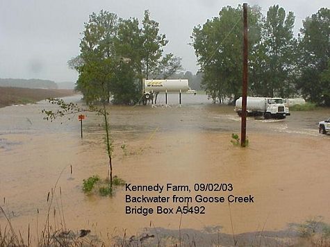
Backwater is the increase in the upstream water surface level resulting from an obstruction in flow, such as a roadway fill with a bridge or culvert opening placed on the floodplain. The normal water surface elevation is the elevation of the water surface across the flood plain without the bridge, culvert, or roadway fill. Backwater is measured above the normal water surface elevation, and is the maximum difference between the normal water surface elevation and the water surface elevation resulting from the obstruction to flow.

Backwater for bridges, box culverts and pipes on all routes shall meet the National Flood Insurance Program requirements. The designer must consider the impacts to upstream improvements, crops and property values as well as the depth, frequency, extent and duration of the backwater impacts. The backwater must be reasonable for the full range of flows less than or equal to the design event. Impact is defined in terms of value and quantity of property that may be affected. Prior to selecting backwater criteria, the potential backwater impacts are evaluated:
- 1) For bridges and boxes in areas with low levels of potential impact, allow from 0 to 2 ft. of backwater over natural in a 100-year event. In areas with moderate to high potential impact allow 0 to 1 ft. of backwater over natural in a 100-year event.
- 2) For pipes with upstream impacts that may be moderate to high, analyze backwater and consider impacts from depth, extent and frequency of flooding for the range of flows.
For projects with moderate or high upstream property impacts, analyze and quantify backwater impacts so that design decisions can be made. This applies even when the District does the design. In some cases, the District may choose to document reasons why backwater impacts do not need to be estimated instead of performing the calculations. The Bridge Division will continue to assess the backwater impacts as part of most hydraulic designs performed by Bridge. Impacts to areas with no existing improvements or anticipated potential for development would be considered minimal, even for relatively large areas. Impacts to agricultural land can be considered minimal if only a small area is affected, or considered moderate to high for a large area.
Consider the extent, depth, duration and frequency of flooding when evaluating backwater impacts. The depth and frequency of flooding are the most critical, but MoDOT can be held responsible for unreasonable increases in any of these.
If it can be assumed that the road won’t be raised in the foreseeable future, consider the flow over the road when sizing the structure. Otherwise, size the structure to handle the full flow so that the structure won’t need to be replaced to raise the road in the future. In this case, the backwater must be specifically calculated for the event that just overtops the road in addition to the standard frequencies. This event may produce the maximum backwater impact.
Choose the upper end of the allowable backwater range only when it is appropriate and reasonable. For new structures the backwater impacts are determined cumulative with bridges left in place. When extending a culvert, a complete hydraulic analysis or documentation of why a complete analysis is not necessary is required. When the existing culvert can be shown to be adequate and impacts from the lengthening are minor, design exceptions can be sought to allow the use of reduced criteria to avoid replacing the culvert. However, a hydraulic analysis is still necessary to determine the impacts.
748.4.2 Backwater from Another Stream
The term "backwater" is also used to describe the increase in water surface elevations near the confluence of one stream with another, caused by flood conditions on the larger stream. In this case, the water surface elevation of the larger stream causes the obstruction to flow for the smaller stream and results in backwater on the smaller stream. When backwater from another stream causes water surface elevations higher than the design high water surface elevation, both elevations shall be shown on the plans.
